Skip to content
n

  • Home
  • Services
    • Surveying
    • Environment
    • Planning & Resource Consents
    • Civil Engineering
    • Structural Engineering
    • Energy
    • Data & Project Management Solutions
    • 3D Laser Scanning
    • UAV Services
    • Geotechnical Services
    • Wai Eye – Water services
  • Projects
  • News
  • About
    • About BTW
    • Our Values & Culture
    • Our People
    • Careers & Vacancies
    • Health & Safety, Environment and Quality (HSEQ)
    • Community
    • Clients & Feedback
    • Memberships
  • Contact
Facebook-f Linkedin-in Instagram
News
  • All News (137)
  • General (78)
  • Environment (18)
  • Planning (14)
    • Resource Consent (11)
  • Surveying (14)
    • Subdividing (6)
  • UAV (5)
  • Infrastructure (13)
  • Covid-19 (7)
  • Community (14)
Menu
  • All News (137)
  • General (78)
  • Environment (18)
  • Planning (14)
    • Resource Consent (11)
  • Surveying (14)
    • Subdividing (6)
  • UAV (5)
  • Infrastructure (13)
  • Covid-19 (7)
  • Community (14)

Preserving history digitally for years to come

  • July 8, 2021
  • Topic BIM, Surveying, Technology

Historical buildings are vanishing from our city skylines due to earthquake prone standards, housing shortages, modern designs or age and integrity of the buildings.

BTW’s Scan-to-BIM service is a great tool for building owners to digitally capture highly detailed data of their assets. 

Asset owners can:

  • Turn this data into virtual tours of existing buildings with Virtual Reality (VR).
  • Produce 2D plans of the internal and external areas and dimensions accurately.
  • Provide models to Architects, Structural Engineers and Designers for the design of retro-fit plans or extensions.
  • Utilise the data for off-site pre-fabrication or project planning.
  • Share the model with off-shore partners.
Cambridge Town Hall. BTW Scan-to-BIM modelling.

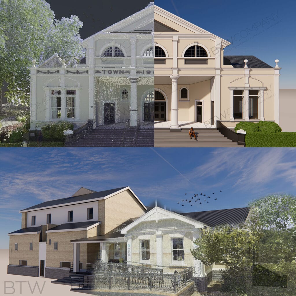
These images of the Cambridge Town Hall compare a highly accurate, surveyed 3D Point Cloud data vs the 3D Model generated by our in house geospatial field and office teams. 

The level of detail modelled can vary from a simple outline through to the finer details of architraves, street furniture, wordings and materials.

If you would like to generate an accurate 3D model of your asset, get in contact with our BTW Geospatial team. info@btw.co.nz

#BIM #VR #modelling #architecture #assetmanagement #pointcloud #waikato #taranaki #surveying #geospatial #preservinghistory

Share this post

PrevPreviousSurf, skate, snow
NextBalancing career and lifestyleNext

New Plymouth
179 Courtenay Street
New Plymouth 4310
New Zealand

06 759 5040​

Hamilton
517 Anglesea Street
Hamilton 3204
New Zealand

07 595 0020

Raglan
1 Wainui Road
Raglan 3225
New Zealand

07 595 0020

Taupō
12 Ashwood Avenue
Taupō 3330
New Zealand

0800 289 787
  • Contact
  • Privacy Policy
  • Site Map
  • Contact
  • Privacy Policy
  • Site Map
Facebook-f Linkedin-in Instagram
  • © BTW Company
  • 2023
  • Website by
Apex Digital